|
The 1996 Laguna Canyon Crop Circle Formation
The worldwide phenomenon of Crop Circles, though predominantly centered in England, has been documented in nearly every country. The United States and Canada each usually record twenty to thirty per year, though the media generally chooses to let them go unreported. California has received at least one genuine crop circle in each of the past three years. The most recent one occurring in Laguna Canyon, California. Our investigation revealed compelling connections between the design and the once indigenous peoples of the area, the Tongva Tribe, whose sacred land and gravesites were being bulldozed in March of 1996 to build a highway.
Fig 1
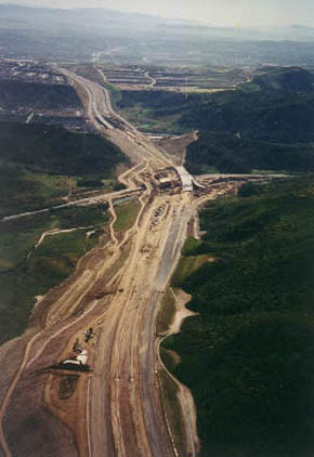
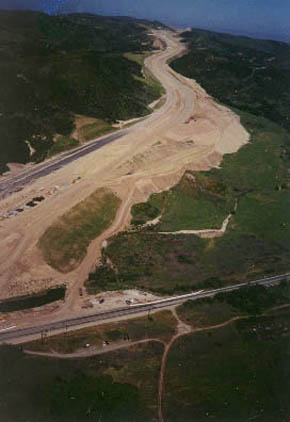
The Laguna Canyon Crop Circle formation was first noticed on the 9th of March by Tom Ross, a local resident of Laguna Niguel, as he was driving toward Laguna Beach, and the first ‘toll road’ overpass under construction, through the remaining ‘Greenbelt’ wilderness area of Laguna Canyon (Fig.1). This is situated off Laguna Canyon Road (Route 133), approximately 50 miles south of Los Angeles, on the California coast. Four weeks later we were notified by Ruben Uriarte (Colin Andrews’ CPRI representative living in Northern California), and on the same day we traveled to Laguna Canyon to photograph, survey, and collect samples of the formation.
Fig.2
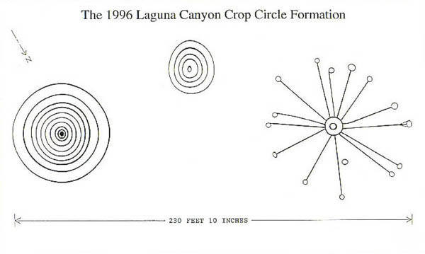
Once on site, we discovered that the formation was comprised of three glyphs: a large ‘concentric’ nine ringed glyph; a small ‘concentric’ five ringed glyph (both elliptical); and a large glyph consisting of two small ‘concentric’ rings, with fourteen thin lines radiating from the larger of the two rings, arranged like the ‘spokes’ of a wheel, each terminated by a small thin ring. One of the spokes split into three paths, forming a ‘claw-like’ design feature, before also joining a thin terminating ring. The thin lines and rings varied in thickness throughout the formation, by a few inches, having an average width of nine inches. The overall width of the entire formation was 230 feet 10 inches (Fig.2).
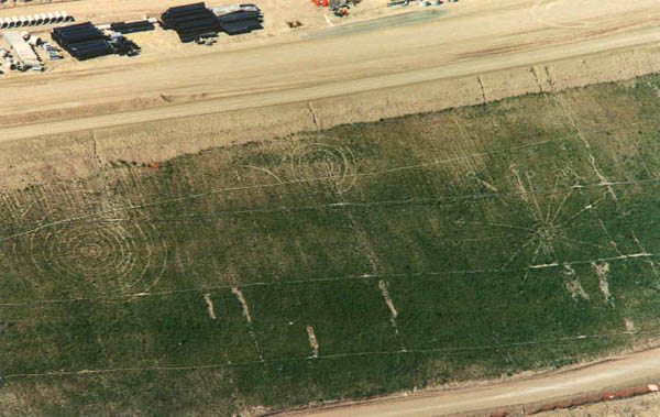
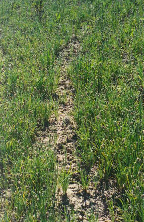
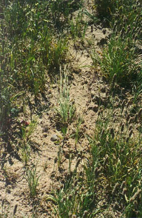
The three glyphs appeared on a steep weed covered construction embankment, adjacent to the toll road overpass. A close look at the formation revealed that the rings and lines were made up of bare earth, with very few plants growing inside them (Fig.3/4). This was interesting because the embankment was otherwise evenly covered with vegetation. There was no sign of any plants having been removed, such as soil disturbance or uprooted plants lying around. There was an absence of foot and hand prints where there would need to be if it were a man-made formation. The angle of the hillside was extremely steep and difficult to traverse. The texture of the soil was powdery, dry and crumbly, and of a consistency that made it impossible to step on without leaving an impression.
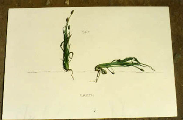
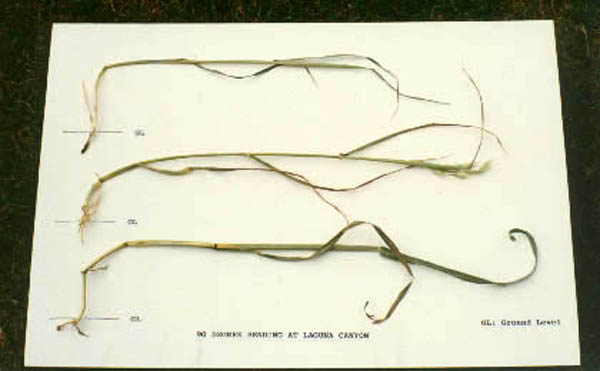
Inspecting the ringed centers we found that the nine ringed glyph had an elliptical bare earth center, with a ‘raised earth ring’ around it, approximately six inches high, while the five ringed glyph, and the spoked glyph, had a flat earth ring around an elliptical center of undisturbed standing plants. Numerous native and non-native plant species covered the hillside (many sown by the construction company building the toll road) but only two: English Plantain and Wild Oats were found to be bent, the latter discovered only in a single ring terminating one of the ‘spokes’ (Fig.5/6).
The overwhelming majority of bent plants were English Plantain, found throughout the formation inside and along the edges of the rings and lines. Was the glyph-creating agent being selective? It seemed more than coincidental. By selecting only English plants was the Laguna Canyon formation meant to be recognized, categorized, and thought of as a Crop Circle event, despite its unique appearance? Also, as with more ‘classic’ looking non-manmade Crop Circle formations discovered in crop fields around the world, and in particular England, both the Plantain and the Oats were clearly bent 90 degrees just above ground level. This was in addition to the natural bend of the plants, and without a break or a crease, with the affected node varying in the Oats. The plants were not pressed into the soil or damaged in any way, but continuing to grow horizontally with their heads and delicate seeds intact. We also noticed that the bent plants found on the outer edge of any ring were splayed outward as if by centrifugal force, and that the direction of the bent plants alternated depending on the ring they were in.
Fig.5
Fig.6
We sent plant and soil samples, taken from many points inside and outside the formation, to W.C. Levengood, a noted biophysicist and expert in crop circle plant analysis, within a day of sampling the formation. His preliminary statement after receiving the first sample package was he ‘very impressed’ with the plant bending. He went on to say that English Plantain was a ‘dicot’, a species of plant that sends two initial shoots through the soil; a characteristic it shares with another plant: Canola or Rapeseed, well known for hosting English crop circles early in the season.
Levengood later completed both the soil and plant analysis and confirmed the authenticity of this formation. Although the soil testing revealed nothing unusual, the cell walls and pits of the bent plants were, he said “abnormally large, well beyond the control samples and statistical expectation. Their appearance resembling cells that had experienced internal heating.” He added in a later discussion “As we have seen in the past, this degree of change in the cell wall pit diameters indicates the plants were exposed to a very rapid, high heat input.” He also confirmed an absence of herbicides in the soil samples, which might have accounted for the ‘bare-earth’ component of this formation.
Fig.7
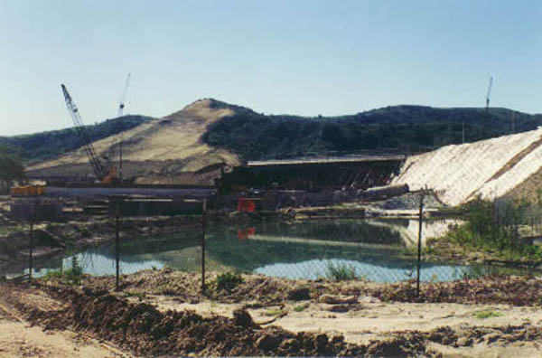
In keeping with the Crop Circle phenomenon the location of the formation was also interesting for its proximity to both above ground and underground water sources. Within a few hundred feet was an artificial pond used by the construction company (Fig.7), and a marshy area known as a ‘vernal’ or ‘Spring pool’, extending into the canyon. Also lying across the embankment, and crossing two of the three glyphs was an irrigation pipe for the seeded hillside.
Fig.8
Researching the possible pictographic meaning of the Laguna Canyon Crop Circle formation, we discovered some intriguing information concerning it design, that is very Native American looking. We discovered that the indigenous people of the area, the Gabrielino or Tongva, and their friendly Northern neighbors the Chumash, both have rock art (Petroglyphs) and a sacred object known as a ‘Sun Staff’ that are strikingly similar to the three glyphs (Fig.8). The sun staff is a steatite stone surmounted on a stick, often incised with rays or geometric designs, representing the declination of the sun or the cardinal points of the Tongva compass. Chumash shamans used these sun staffs in their all important solstice ceremonies, where the shaman would tap the stone three times and then symbolically pull the sun back from its most Northern position (during Winter solstice) towards its most Southern position (at Summer solstice), signifying and celebrating the end of Winter and the beginning of the sun’s return. Were the three glyphs to represent the three ‘taps’? Suspecting the ‘spoked’ glyph to represent a sun staff we measured the angles of the 14 spokes and discovered a spoke aligned with each of the following: Winter Solstice Sunrise, Winter Solstice Sunset, and Summer Solstice Sunrise.
Additionally, we learned of some interesting accounts of a Tongva hero, by the name of ‘Chingichnish’, a spiritual leader said to have appeared hundreds of years ago to teach the people how to live in harmony with ‘Nocuma’ (The Great Spirit), that seemed to also relate to the Laguna Canyon formation. He said that Nocuma would give three warnings to people who failed to respect the land, and if they were ignored then nature would take its course. The Laguna Canyon Crop Circle pictogram was comprised of three glyphs, and appeared at a site where there had recently been considerable local protest against the building of the toll road, cutting a wide path through the last small piece of remaining wilderness of Laguna Canyon (Fig.9/10).
It was reported that a number of ‘solstice caves’, sacred to the Tongva, had been destroyed in the process. Also, several thousand people had marched in protest against the construction, but their demonstration had fallen on ‘deaf ears’. Then, some months after the formation, the immediate area was hit by two devastating events: a major scrub fire that destroyed large areas of vegetation overlooking the canyon, and a flood, that triggered a major hill collapse and mudslide, that caused considerable property damage in the same area. A coincidence? Or was it another sign of Nocuma, like the formation, of what would happen if we fail to respect the land, in this case, by putting land development before land preservation?
Another possible correlation of interest was the timing and design of the Laguna Canyon pictogram to the appearance of Comet ‘Hyakutake’, in the mid-March sky, a comet that was most visible from Southern California on March 25th 1996. During the previous summer in Hampshire England, two crop circle formations in particular seemed to depict our solar system, with circles representing the sun, neighboring planets, their orbits, and the ‘Asteroid Belt’. In 1994 the ‘Shoemaker-Levy 9’ Comet crashed into Jupiter and was also depicted in a series of formations. It was interesting to see how consecutive years formations and themes ran together. At Laguna Canyon, like in England in 1995, many circles, in the form of rings attached to spokes, formed a ‘ring’, not unlike a variation on the theme of an asteroid belt, around a common center.
Since the impact of the Shoemaker/Levy 9 comet event 1994 a great many people have become a lot more aware of the warnings of scientists and astronomers, particularly through films and television documentaries, about the very real danger posed by large Earth colliding asteroids and comets. In the crop fields in England in 1995, one of the Hampshire ‘Asteroid Belt’ looking crop circle formations even depicted the Earth ‘missing’ from its orbit. Seeing a connection in the design of this formation, and an earlier one that appeared near Alresford in Hampshire on June 18th 1995, to the Laguna Canyon pictogram, we showed a photograph of the latter formation to a Chumash Elder at a local native American gathering, to see if he could identify the pictogram symbols. Not sharing what we had learned first he instantly confirmed that he recognized the formation from his own peoples’ rock art. After looking at the spoked glyph he pointed to the unattached circle between two of the spokes and said “Something within us is bringing destruction from out there” as he pointed up into space. Could this be one of the meanings of the Laguna Canyon formation? Could it be a warning that we need to change, or change will be brought to us?
The
Laguna Canyon crop circle was the first genuine formation of 1996 to
appear in the Northern Hemisphere, truly embodying the now familiar
characteristics of the non-manmade phenomenon.
Copyright
2001-2009 Ed & Kris Sherwood |
Sunstaff.jpg)
